

Chief Buffalo's Reservation
In the Treaty of 1854 treaty signed at La Pointe, Chief Buffalo reserved a one-mile square piece of land. He chose a section of land that may have been intended to incldue the Indigenous burial ground at Rice’s Point, though that site was not included in any of the various versions of the reservations boundaries. Today, the reservation would include portions downtown Duluth, as well as the neighborhoods of Canal Park, Lincoln Park, Rice’s Point, Central Hillside.
Chief Buffalo died within a year of the signing of the treaty, and the ownership of the reservation continues to be a point of controversy. Frederick Prentice purchased part of the property in 1856 and began a series of lawsuits to reclaim the reservation land he felt belonged to him. The first court case file in St. Louis County was a 1859 lawsuit over Chief Buffalo’s reservation land. There was publicity in the 1980a and 1890s contesting ownership of the reservation land. This led to knowledge in Duluth that much of the city was being built on reservation land, and development halted. In 1911, some descendants of Chief Buffalo reportedly began to file claims to the land within Chief Buffalo’s reservation, although no file claims have been found. As recently as 1979, a story in the Duluth Herald reports talk of Chippewa reviving claims to the land, but as of 2015, no lawsuits have been filed on behalf of Ojibwe reclaiming Chief Buffalo’s reservation land.
Interestingly, under the 1854 Treaty, a provision was made that no alcohol could be produced, sold or consumed on Chief Buffalo’s reservation land. This would be in effect until ordered otherwise by the President of the United States. In 1911 President Taft signed an executive order rescinded the alcohol prohibition of the 1854 Treaty—except for the boundaries of Fond du Lac reservation.
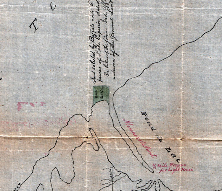
One version of the boundaries for Chief Buffalo's reservation is shown at the base of Minnesota Point in a detail from an 1857 map preserved in the National Archives in Washington, D.C. Other maps show a larger and more irregularly shaped versions of the reservation boundary, though centered on the same area.
1854 Treaty at La Pointe
Establishment of the Bad River Reservation and Chief Buffalo’s Reservation in Article 2, Section 6
“The Ontonagon band and that subdivision of the La Pointe band of which Buffalo is chief, may each select, on or near the lake shore, four sections of land, under the direction of the President, the boundaries of which shall be defined hereafter. And being desirous to provide for some of his connections who have rendered his people important services, it is agreed that the chief Buffalo may select one section of land, at such place in the ceded territory as he may see fit, which shall be reserved for that purpose, and conveyed by the United States to such person or persons as he may direct.”
Copyright © 2022. All rights reserved.